


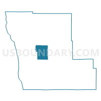
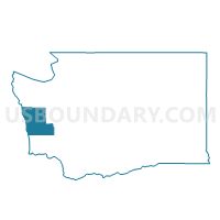
Axford Voting District, Grays Harbor County, Washington
About
Outline

Summary
| Unique Area Identifier | 684387 |
| Name | Axford Voting District |
| County | Grays Harbor County |
| State | Washington |
| Area (square miles) | 64.59 |
| Land Area (square miles) | 64.38 |
| Water Area (square miles) | 0.22 |
| % of Land Area | 99.66 |
| % of Water Area | 0.34 |
| Latitude of the Internal Point | 47.15094210 |
| Longtitude of the Internal Point | -123.94004130 |
Maps

Graphs
Select a template below for downloading or customizing gragh for Axford Voting District, Grays Harbor County, Washington


Neighbors
Neighoring Voting District (by Name) Neighboring Voting District on the Map
- Hoquiam Rural Voting District, Grays Harbor County, WA
- Humptulips Voting District, Grays Harbor County, WA
- Wilderness Voting District, Grays Harbor County, WA
- Wishkah Voting District, Grays Harbor County, WA
Top 10 Neighboring County Subdivision (by Population) Neighboring County Subdivision on the Map
- Ocean Shores CCD, Grays Harbor County, WA (7,599)
- Wishkah CCD, Grays Harbor County, WA (1,448)
- Humptulips CCD, Grays Harbor County, WA (1,268)
Top 10 Neighboring Unified School District (by Population) Neighboring Unified School District on the Map
- Hoquiam School District, WA (10,797)
- Lake Quinault School District, WA (1,187)
- Wishkah Valley School District, WA (835)